3D Earth & Area Measure – iOS Source Code
3D Earth & Area Measure is a next-generation iOS app that brings together the power of 3D maps, real-world navigation, and accurate land measurement tools — all in one seamless experience. Built using Swift + SwiftUI, this ready-to-launch source code gives developers, map enthusiasts, and businesses the ability to create a high-performance land measurement and 3D navigation app designed for precision, realism, and ease of use.
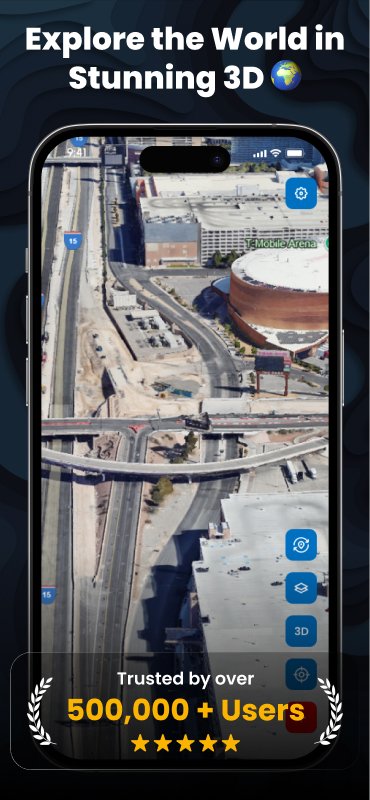
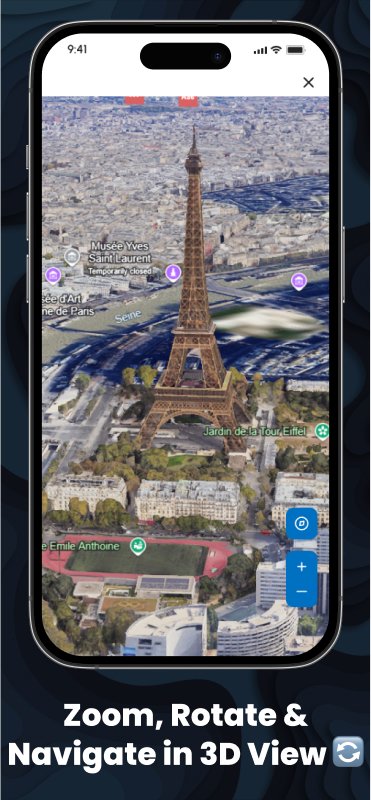
With 3D Earth & Area Measure, users can explore the world in immersive 3D, measure any land area or distance, and save custom placemarks directly on the map. Whether you’re a traveler, builder, surveyor, or developer, this app delivers an unmatched mapping experience with smooth 3D zooming, rotating, and navigation controls. Users can measure land plots, property boundaries, or routes in just a few taps — all while visualizing the terrain and environment in stunning 3D detail.
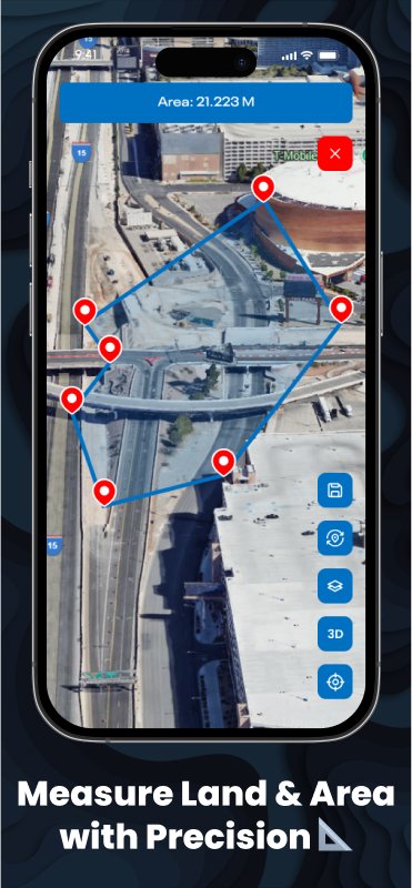
This modern mapping app is powered by real-world satellite imagery and GPS-based measurement technology, ensuring precise area calculations for land and distance measurement. The intuitive interface allows users to pin multiple points on the map to measure custom areas or distances instantly. From agriculture and construction to urban planning and travel, this tool is perfect for professionals who demand accuracy and visual clarity.
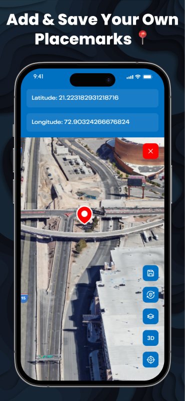
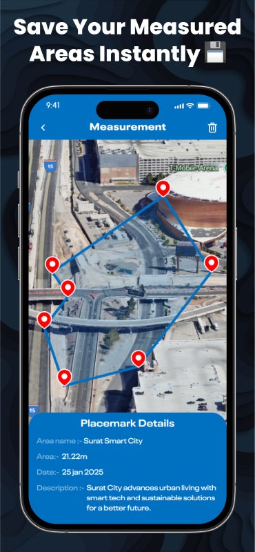
The 3D Earth & Area Measure App gives users full control to add, edit, and save placemarks, allowing them to label important locations with latitude, longitude, and personal notes. Each saved measurement displays details such as total area, perimeter, coordinates, and date, making it easy to manage multiple projects. This functionality turns the app into a powerful land management and measurement system, not just a simple 3D viewer.
3D Earth & Area Measure isn’t just another mapping tool — it’s a revolutionary app experience that combines real-world accuracy, high-definition 3D visualization, and user-friendly design to help you measure, explore, and discover the planet like never before.
What Does This Product Offer You
You’ll receive the complete iOS source code for the 3D Earth & Area Measure app — exactly as shown in the demo.
- 3D Map Experience: Explore the world in realistic 3D satellite view.
- Land & Area Measurement: Measure land areas and distances with pinpoint accuracy.
- Custom Placemarks: Add, edit, and save your favorite locations easily.
- Instant Save Feature: Store and organize your measured areas for future reference.
- Smooth 3D Controls: Zoom, rotate, and navigate effortlessly.
- Professional UI: Designed for modern iPhones and iPads with a clean, intuitive interface.
- Documentation Included: Step-by-step PDF guide for setup and customization.
What Do I Need To Get Started
- Mac computer with Xcode 15+ installed
- iOS 14+ device (iPhone or iPad)
- (Optional) AdMob for ad integration
- (Optional) Firebase for saving user data and measurements online
- Basic Swift/Xcode knowledge (Documentation included for beginners)
How Does it Work
Users can explore real-world locations in 3D, add their own placemarks, and measure areas directly on the map. All measurements can be saved and viewed later, making it ideal for land surveys, travel.
What’s Included
- Full iOS source code for X Browser
- Demo project with sample settings and UI
- High-quality screenshots for listing
- Detailed setup and customization documentation
- Support for Xcode 15+ and iOS 14+
- Ready for resale or commercial use
Target Audience
Perfect for:
- Developers: Want to create a 3D map or GPS-based tool fast.
- Land Surveyors & Professionals: Who need accurate area measurement tools.
- Construction & Real Estate Firms: For property visualization and boundary mapping.
- Students & Learners: Interested in GIS, 3D mapping, or iOS development.
Why Choose This App?
- Quick Launch: Production-ready code built in SwiftUI.
- High Accuracy: Precision tools for land & area measurement.
- Modern 3D Experience: Real-world visualization in 3D satellite mode.
- Fully Customizable: Rebrand, modify, or add features easily.
- Complete Documentation: Simplified setup and configuration guide included.
Price: $99
We’re confident in the quality of our products — that’s why we offer unlimited FREE support to every customer.