Blog
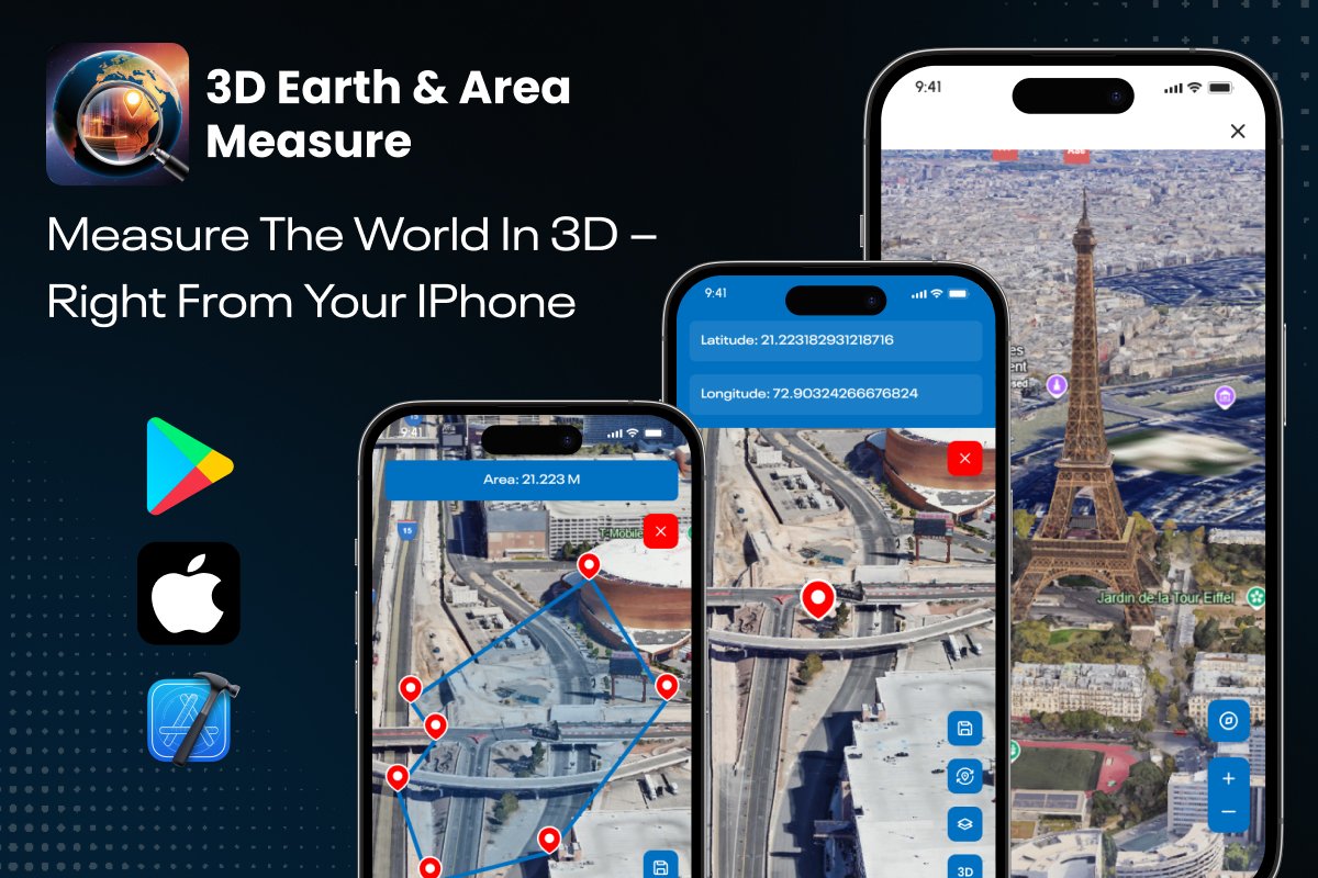
Globe Earth 3D - iOS Source Code | Build Your Own 3D Mapping & Land Measurement App
3D Earth & Area Measure – iOS Source Code is a complete, production-ready solution for developers who want to launch a premium 3D globe earth app, area measurement tool, and field mapping system without building everything from scratch. This powerful package includes full iOS source code, a stunning UI kit, and a fully functional app template that’s ready to be rebranded, redesigned, and published on the App Store instantly.
Designed to impress both developers and end-users, the app offers a unique combination of 3D Earth visualization, satellite mapping, and precise field area measurement tools. Users can explore any location on the planet in high-quality 3D, draw shapes to calculate area, measure distances, drop placemarks, and save their mapped regions instantly. For developers, this makes the app extremely marketable in categories like land surveying, exploration, real estate, field mapping, and educational geography tools.
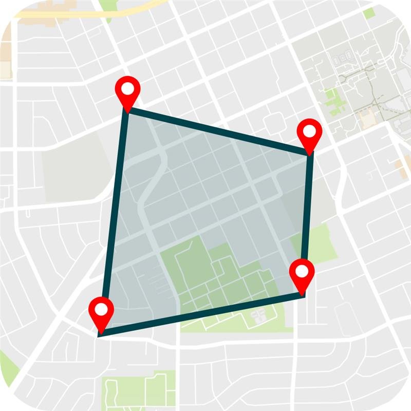
At the core of the app is a powerful Area Measurement engine that allows users to tap around any region on the map and get accurate results within seconds. Whether measuring a property, farmland, construction zone, building rooftop, or any outdoor location, the system calculates the total area precisely, supporting multiple units such as square meters, square feet, acres, and hectares. The smooth polygon-drawing interface and GPS-backed calculations deliver a professional land surveying experience.
The app also includes a smooth Distance Measurement feature, letting users calculate the distance between multiple points on the 3D globe or satellite map. This is ideal for engineers, GIS professionals, travelers, and outdoor planners who need instant path measurement tools.
One of the standout features is the ability to add, save, and manage Placemarks. Users can drop a pin anywhere on the 3D globe earth, view latitude/longitude, and store the coordinates for later use. This is extremely useful for surveyors, construction professionals, researchers, and even students learning geography. The saved areas and placemarks can be revisited anytime, making the app a practical mapping assistant.
🔹 Full iOS Source Code – Clean, production-ready Swift project for fast customization.
🔹 3D Earth Visualization – Navigate, rotate, and zoom anywhere in the world with smooth 3D rendering.
🔹 Accurate Land & Area Measurement – Draw custom polygons to measure fields, plots, and regions precisely.
🔹 Add & Save Placemarks – Drop pins with latitude/longitude details and save for later use.
🔹 Offline Measurement Access – Save measured data instantly on-device.
🔹 Beautiful Modern UI/UX – Optimized for iPhone with dark/light mode support.
🔹 Easy Rebranding – Change app icons, name, and theme in minutes to create your own version.
🔹 Ready for App Store Submission – Fully tested, stable, and designed to meet Apple’s UI guidelines.

Perfect For
iOS Developers & Agencies – Save development time and deliver apps faster.
Tech Startups – Build innovative geo-based tools without coding from scratch.
Mapping, Surveying & Real Estate Businesses – Offer users accurate land measurement and navigation features.
Freelancers – Rebrand and sell under your own app label or portfolio.
Why Choose Softmize App Studio?
At Softmize App Studio, we craft high-quality Flutter and iOS source codes that accelerate your app launch. Every template is:
✅ Optimized for Performance & SEO
✅ 100% Customizable
✅ Built with Modern Architecture
✅ Trusted by 500,000+ Developers Worldwide
What’s Included
Complete iOS Swift Source Code
Clean UI & UX Design Components
Dedicated Developer Support